Trail Walking La Palud-sur-Verdon - [Itinéraire] Le sentier du Bastidon - Photo
© OpenStreetMap contributors
Length
Length
15.3 km
Max alt
Max alt
1383 m
Uphill gradient
Uphill gradient
877 m
Km-Effort
Km-Effort  
27 km
Min alt
Min alt
701 m
Downhill gradient
Downhill gradient
877 m
Boucle
Boucle
Yes
Creation date :
2020-04-22 13:26:13.476
Updated on :
2020-04-24 22:59:01.219

(0 Reviews)

Walking
Walking
5h28
Difficulty : Very difficult

Scan this QR Code to open this trail in the SityTrail application

FREE GPS app for hiking

Logo SityTrail SityTrail

IGN / Geographical institutes

Download SityTrail from the App Store Download SityTrail from Google Play

Logo SityTrail SityTrail World

The world is yours!

Download SityTrail from the App Store Download SityTrail from Google Play Download SityTrail on Huawei AppGallery

About

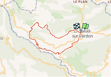
Trail Walking of 15.3 km to be discovered at Provence-Alpes-Côte d'Azur, Alpes-de-Haute-Provence, La Palud-sur-Verdon. This trail is proposed by Kristine83500.

Elevation profile

Positioning

Country:
France
Region :
Provence-Alpes-Côte d'Azur
Department/Province :
Alpes-de-Haute-Provence
Municipality :
La Palud-sur-Verdon
Location:
Unknown
Start:(UTM)
285939 ; 4850841 (32T) N.

Trails nearby

Trail Walking Rougon - Gorges du Verdon - de Point Sublime vers Encastel - AR - Photo
Walking
GUIDE
Orcal37

Walking

Medium
(2)
Rougon, Provence-Alpes-Côte d'Azur, Alpes-de-Haute-Provence, France
9.3 km | 18.6 km-effort
3h 15min
Yes
Trail Walking Rougon - Sentier Martel.Gorges du Verdon.06 05 16 - Photo
Walking
Dervalmarc

Walking

Medium
(3)
Rougon, Provence-Alpes-Côte d'Azur, Alpes-de-Haute-Provence, France
12.1 km | 26 km-effort
6h 20min
No
Trail Walking Aiguines - Belvédère, gorges, Inbut, sentier Vidal - Photo
Walking
MarcLEBARON

Walking

Difficult
(3)
Aiguines, Provence-Alpes-Côte d'Azur, Var, France
9.3 km | 20 km-effort
3h 35min
Yes
Trail Walking La Palud-sur-Verdon - Sentier Blanc-Martel - Photo
Walking
i20

Walking

Medium
(2)
La Palud-sur-Verdon, Provence-Alpes-Côte d'Azur, Alpes-de-Haute-Provence, France
15.4 km | 31 km-effort
Unknown
No
Trail Walking La Palud-sur-Verdon - Verdon : Sentier Blanc Martel - Photo
Walking
manumax

Walking

Medium
(1)
La Palud-sur-Verdon, Provence-Alpes-Côte d'Azur, Alpes-de-Haute-Provence, France
16.1 km | 39 km-effort
6h 43min
No
Trail Walking La Palud-sur-Verdon - Gorges du Verdon - La-Palud-sur-Verdon - Tour de la cime de Barbin - Photo
Walking
GUIDE
Orcal37

Walking

Medium
La Palud-sur-Verdon, Provence-Alpes-Côte d'Azur, Alpes-de-Haute-Provence, France
13 km | 20 km-effort
4h 15min
Yes
Trail Walking La Palud-sur-Verdon - bastidon - Photo
Walking
xav34830

Walking

Medium
(1)
La Palud-sur-Verdon, Provence-Alpes-Côte d'Azur, Alpes-de-Haute-Provence, France
18.4 km | 33 km-effort
Unknown
Yes
Trail Walking La Palud-sur-Verdon - sentier blanc Martel depuis Chalet les Malines - Photo
Walking
PVERTICAL

Walking

Difficult
La Palud-sur-Verdon, Provence-Alpes-Côte d'Azur, Alpes-de-Haute-Provence, France
17.6 km | 39 km-effort
4h 37min
No
Trail Walking Aiguines - sentier de l'imbut par les cavaliers - Photo
Walking
PVERTICAL

Walking

Difficult
Aiguines, Provence-Alpes-Côte d'Azur, Var, France
14 km | 38 km-effort
4h 58min
Yes


Close
My subscriptions